|
 |
 |
|
|
|
 |
 |
 |
|
|
|
Project Description
Introduction
Peru is the fourth largest country in Latin America (+1,285,000 sq km) and the fifth most populous (ca. 24,000,000 inhabitants). Owing to its geographic position, it contains a wealth of biodiversity, both plant and animal. The process of documenting Peru's rich environments continues, but recent compilations estimate that it contains no fewer than 19,000 species of flowering plants, gymnosperms, and ferns (roughly 20% of the entire South American flora). Peru is widely recognized as one of the twelve major centers of origins for world food plants. The eastern Amazonian rain forests comprise over 60% of Peru's total area and represent an important natural resource. A primary problem facing Peru is the establishment of priorities for utilization, management, and protection of its natural resources.
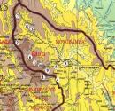
In the Department of San MartÚn in northeastern Peru, the upper elevation montane forests and the ceja de la montaþa (the eyebrow of the forest) give way to the lowland rain forests of the Amazon basin. The forests in this area are termed Selva Alta or premontane forests that range roughly between altitudes of 500-1500 m. Over the last two decades, the population of northeastern Peru has grown rapidly and this growth has resulted in the exploitation of unprotected forest. In regions that have suffered clear-cutting of the forests, soil erosion, landslides, floods, and diminished seasonal water supplies have resulted (Gentry & Lopez-Parodi 1980). In 1986, amid fears that continued logging would directly threaten their watershed, local leaders in Rioja, San Martín, requested that the forests in the headwaters of the Río Alto Mayo and its tributaries be protected. The Peruvian government set aside a large portion of these forests under the protected status of Bosque de Protección Alto Mayo (Figure 1), an area roughly representing the watershed of the RÚo Alto Mayo in extreme northwestern San Martin. Given that rice production was one of the regions exports, a significate loss of water would threaten the area's agricultural base. Conservation assessments for the eastern slopes of the Peruvian Andes have been summarized (Young & Leµn 1997). As they point out, but a few locations have been studied in detail. Three National parks along the eastern slopes have suffered from indiscriminate cutting. Clearly the designation of Bosque de Protecciµn has not functioned to save the forests of the Alto Mayo.

Figure 1. Bosque de Protecciµn Alto Mayo |
 |
Solid line indicates the approximate boundary |
Collecting Expeditions and Results
With National Geographic support, five collecting expeditions were conducted, one each in 1996, 1997, 1998, 1999, and 2000. The collecting team consisted of Dr. Isidoro SÃnchez-Vega (Director of Herbarium, CPUN), Gustavo Iberico Vela (Botany Professor, UNC), Mario Zapata (Museum Assistant, UPAO), Roberto DiÕguez BazÃn (Rioja), and the Dr. Michael Dillon (Field Museum, Chicago), began work in the Rioja area. Sr. Julio Hidalgo provided help in field studies. The forests of the Bosque de Protección Alto Mayo represent 182,000 hectares and is the largest remaining tract of Selva Alta in northeastern Peru.
Sampling during the each field season concentrated upon unexplored and under collected areas within the forests. The collections represent the first intensive collecting in the region since that of Llewelyn Williams in the 1920's. The team has visited the watershed forests of many of the tributaries of the RÚo Alto Mayo, including collecting along the RÚos Naranjo, Soritor, Yuracyacu, Negro, and Tochima. Several localities have been visited more than once, to provide a more complete census of their floras.
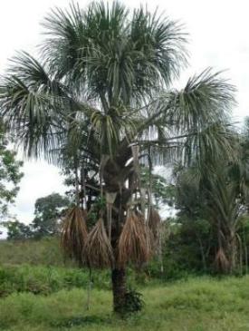 Mauritia flexuosa (Arecaceae) (common name: aguaje) is the most common palm found in lowland areas and often occurring in seasonally inundated habitats ("aguajal"). | 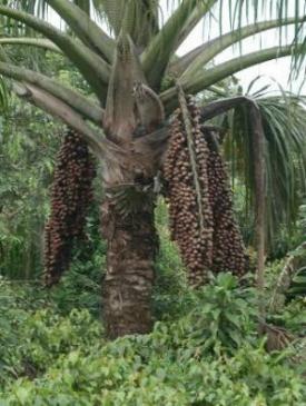 The fruits are used for making beverages and eaten when ripe. |
 The forests around Laguna ONERNCOCHA a lake near Aguas Verdes and further distant localities within the boundaries of the protected forest have been surveyed. The lake is said to cover an area of over 10 hectares and to be over 50 meters deep. At 1100 meters, the vegetation at the margins is quite unlike that of surrounding "selva alta" and some elements from lower riparian habitats such as Hillia ulei (Rubiaceae). The region around the lake has been largely protected from logging and it is hoped that a pollen core from this locality may tell us much about the past climate changes in the region.
 |
  |
| We have explored into Department Amazonas on a trail from Naciento de RÚo Negro (a town less than 10 years old) to Vista Alegre, a trial that eventually leads to Molinopampa and ultimately Chachapoyas. Llewelyn Williams (see below) used this same trail on his journey to Chachapoyas in 1930. The region has largely been overcut and forest is confined to upper portions of higher slopes. From Vista Alegre to RÚo Salas, the forest is very disturbed and remnants of coca (Erythroxylum sp.) production were evident. In the early 1980's the region was the site of considerable illegal coca cultivation, but today the area does not appear to be producing coca for the commercial trade. | 
|
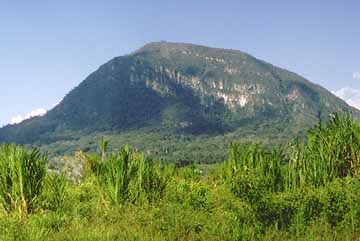 | Another interesting locality within the highly disturbed central basin of the Río Alto Mayo is Morro Calzada. The Morro has been managed as a nature reserve for several years and is a frequently visited recreational area just 2 kms from the town of Calzada. For more about the Morro Calzada. |
While the majority of the collections have not been identified to species, preliminary results point to high levels of diversity in several families. When more material is identified, we can begin comparing generic and species complements from our montane forest inventories (Dillon 1994, Dillon et al. 1995). Our collecting efforts in the Alto Mayo forests have encompassed no fewer than 118 families, 378 genera, and no fewer than 580 species.
| Historical Results In addition to the collections generated by this project, we are adding to the database the ca. 7800 records taken from the collections made in this region
by Field Museum botanist |
 Llewelyn Williams in 1929/30 (Williams 1936). Williams research was
focused on economically important lumber species and his collection vouchers are
still housed at Field Museum. Some important species, such as Swietenia macrophylla (Peruvian mahogany), were stated to have been considerably more frequent 68 years ago; we have not encountered a single individual in our collecting. Some of Williams' observations are interesting in the light of the current peril that the forest are in. Williams (p. 41, 1936) notes:
Llewelyn Williams in 1929/30 (Williams 1936). Williams research was
focused on economically important lumber species and his collection vouchers are
still housed at Field Museum. Some important species, such as Swietenia macrophylla (Peruvian mahogany), were stated to have been considerably more frequent 68 years ago; we have not encountered a single individual in our collecting. Some of Williams' observations are interesting in the light of the current peril that the forest are in. Williams (p. 41, 1936) notes:
| "The exploitation of certain timbers, while not of large magnitude in relation to the extent of the forests, is progressing slowly, although handicapped by the isolation of the territory, the high freight rates, and unlike the conditions prevailing in some other tropical countries, the great distances that have to be traversed within the montaþa before finding timbers suitable for market. In some instances, logs have to be floated for several hundred miles to the shipping point." |
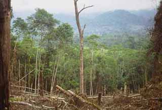
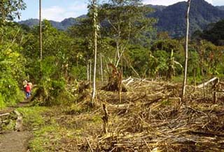
Our collecting and documentation began in 1994 and our data, like that of Williams before us, will provide another benchmark for this region. We have continued to visit a variety of different areas within the forest. The destruction of the forest continues, even though the boundaries of the protected forest are widely known. In some cases, selected large trees are removed with minimal overall damage to the forest. The heartwood is made into planks and moved by horse or oxen overland and then transported as rafts to market. Other areas are simply clear-cut without regard to future consequences. More and more, areas we sampled the previous year are found clear-cut and diversity eliminated.
Population growth is expanding and a constant influx of migrants has lead to deep intrusions into the forest, where clear-cutting is largely unchecked. As the region's productivity has increased, so has the need for small settlements that provide a market head for produce. One of the more profitable crops is coffee which only takes a few years from clearing land, planting small shrubs, and tending them for 2-3 years before the first crops begin. Photograph shows coffee drying in new town, Paraiso, north of Aguas Verdes.

One important economic plant that may be in peril through habitat destruction is Carludovica palmata Ruiz & Pav. (common name: "bombonaje"), a palm-like member of the Cyclanthaceae. The fibers derived from unopened leaves are used to make the "Panama" hats famous from this area and an assortment of items for everyday use and tourist gifts. 

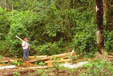
Remnants of a recently poached tree. The trunks are cut
into boards and either hauled out by horses or oxen and rafted on tributaries
to suitable markets.
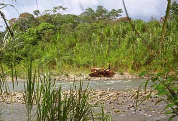
Raft constructed of rough-sawed planks illegally cut and
readied to be floated down the river for sale in Rioja or points south
along the river.
Clear-cutting forests within the protected boundaries of the Bosque de Protecciµn Alto Mayo.